Characterization of Geological Reservoirs
Presentation of the team
The aim of the CRG (Characterization of Geological Reservoirs) team, led by Daniel BRITO, is to analyze properties and characteristics of geological reservoir systems. Reservoir systems can be considered on a scale ranging from a meter to several kilometers and are the geological interface that enables the integrated analysis of all the processes at play in the construction of a sedimentary basin. The processes involved are played out at basin scale and right down to that of the pore network, linking solid rock and fluid layers. The team’s activities combine geological approaches (structural geology, sedimentology, geochemistry, geomorphology and neo-tectonics) with geophysics, rock physics and mineralogy.
Research activities
A) Tectonic interaction and sedimentation (basin dynamics)
Basin dynamics is one of the CRG team’s core subjects. Home to the majority of natural resources and resulting from the competition between orogenic and extensional processes, the sedimentary basin is at the interface between surface processes and geodynamics, between erosion and sedimentary rock development. Understanding it requires, more than anything else, an extremely advanced integration of the processes at play across an incredibly wide range of scales in space and in time.
The CRG team has undeniable competencies in this area: our approach consists first and foremost in the joint characterization of the sedimentary and structural evolution of the objects studied to propose a general study framework and a scalable architecture. Once defined, this framework is filled with quantitative data (sequential stratigraphy, kinematic scenarios, temperature and pressure conditions, etc.) to improve our description of the subsurface and our capacity to estimate its characteristics. This work is based first on a quantitative analysis of data (seismic, wells, field, surface imaging, etc.) used to construct the geomodel, with special importance being given to the description of links between the tectonic structures and the evolution of sedimentary landscapes and facies. The geomodel is then populated with information resulting from data analysis and interpretation, such as quantitative measurements of rock and mineral properties that are the focus of the study (paleo-temperature, paleo-piezometer, the composition of fluids in place, etc.).
We are particularly interested in:
a) Foreland basin dynamics that enable the constant recording of all the steps in the evolution of an orogeny and its propagation. Two work sites in particular are closely monitored: (1) The Neuquen basin at the Andes thrust front in Argentina, perfect for studying the dynamics of intramontane sedimentary basins (Huygues et al., 2015a, 2015b), that witnessed the different stages in the construction of the mountain range and the joint crustal and lithospheric response, including in past recorded events (fault families, Branellec et al. 2015a, b), and its present dynamics (Messager et al. 2010; Branellec et al., 2017); (2) the Jaca basin south of the Pyrenees which enables us to monitor the interaction between the propagation of fold and thrust fault systems and the associated sedimentary architectures, but also the marks of reservoir damage (fracturing, deformation of the matrix, mineralization) (Crognier et al., 2017 ), all key records of the deformation conditions.

Characterization of two fluid circulation episodes (E1 and E2) in the Jaca basin (Crognier et al, 2017).
b) Salt tectonics. The creep capacities of evaporitic series give this particular type of geology exceptional characteristics. Salt is sensitive to the slightest stimulation and amplifies the entire geological dynamics. Some of the highest-producing petroleum provinces in the world are directly controlled by evaporite creep (Angola, Gulf of Mexico, and closer to home, the North Sea field and even certain parts of the Aquitaine region in France). A particularly unique site, the Sivas basin in Turkey (Callot et al. 2014), enabled us to run a comprehensive study of an under-explored basin, starting out with the cartography, the sedimentary analysis (Ribes et al., 2015; 2017), the relation with tectonics (Kegaravat et al, 2016) the integration of fluid / rock interactions (Pichat et al. 2017), and the integration in a regional setting. This work has paved the way to an advanced analysis of the age and extent of this type of structure in the Pyrenees and the Alps. As a logical continuation to this work, we are now looking into a possible analogy between the deformation of clay series and those found in salt-bearing series.
c) These approaches combining tectonics and sedimentation also contribute to the development of original quantification techniques such as the fine dating of deformation episodes through the mineralization of fault families using innovative methods (see below), relative dating of thermal effects and deformation episodes and the relation to mineralization phases.

Partitioning of the deformation in the folded chain of Sivas according to disconnection by the salt canopy (Kergaravat et al., 2017; Legeay et al. submitted).
B) Fluid-rock interaction and diagenesis
We work to identify and quantify the mineralogical and geochemical changes associated with the burial of reservoir rocks and source rocks. Such changes, related to variations in T, P and fluid composition during the burial, deformation and exhumation phases throughout the geological history of the sedimentary basins - and in some cases, the orogeny - have a dominant impact on the reservoir properties (porosity, permeability, mechanical properties) and therefore on their quality in terms of resources (oil, gas, water, geothermal aspects, etc.) and storage. The approaches we use include the petrographic study of samples taken in the field or from drilling cores (optic microscopy, cathodoluminescence, SEM, QEMSCAN, etc.), the geochemistry of isotopes and trace elements (microprobe, ionic probe, IRMS, etc.) Moreover, quantifying the chronology and the duration of diagenetic processes is a major challenge that we tackle by developing U-Pb dating techniques using LA-ICP of carbonates - minerals that are omnipresent in reservoir systems. In the long-term, this kind of approach must enable us to state the basic steps in the evolution of minerals and reservoir damage.
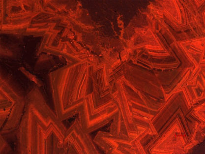
Cathodoluminescence image of dolomite cements in a tectonic breccia (carbonates of the Upper Jurassic, Chaînons Béarnais, SW France).
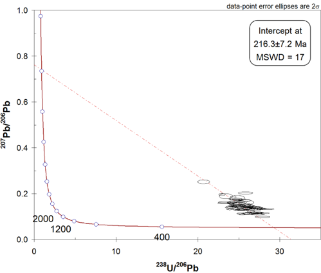
Example of calcite dating using the U-Pb method (Tera-Wasseburg diagram)
C) Quantification of deformation processes and conditions
a) Damage to the matrix in reservoir rocks Damage to a reservoir rock is materialized by a change in the properties of the matrix, and by the development of structures at a larger scale, combining layers of compaction, fracturing, cleavage and faults. We identified a site in Sigues (Aragon) where the exceptional field conditions mean that we can monitor a damage gradient at ridge scale. In this project a great many techniques were used to characterize the deformation of the matrix (anisotropy of magnetic susceptibility (AMS) for clay formation, micro-tomography for the formation of quartz and calcite, FIB-SEM, SEM, X-ray diffraction) and field studies to understand the origin of these deformation phenomena.
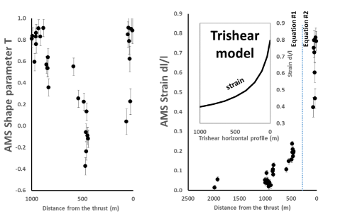
Formation of clay measured using anisotropy of magnetic susceptibility (AMS). Left: evolution of the T form parameter compared with the distance from the thrust fault. Right: deformation (dl/l) modeled using the hypothesis of a rigid rotation of clays (Aubourg et al., AAPG, 2018).
b) Paleo-topography of the sedimentary domains of extended margins The Chaînons Béarnais are a relic of the sedimentary series developed along the hyper-extended and hot margins of the North Pyrenees, are considered as barely deformed by the Pyrenean orogeny. A thermal (Raman spectroscopy), paleomagnetic and field approach helps constrain the paleo-structure of the Chaînons Béarnais and to validate the hypothesis of early deformation during the development of the passive margin. Moreover, our approach enables us to map the sectors that were reworked during Pyrenean compression and to constrain the method of closure for a hyper-extended margin.
Map showing the location of paleomagnetic data indicating the mineral type (magnetite and pyrrhotite) and the recorded polarity (Menant et al., RST, 2016).
D) Multi-physical approach to wave propagation in the laboratory
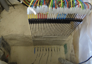
The aim here is to reproduce in the laboratory, the analog of tools used in geophysical prospection at field scale. Experimental activities are focused on mechanical or electromagnetic wave propagation in consolidated porous (natural rocks) or non-porous (sand) media, of different sizes (cm to m) and homogenous to very heterogeneous (e.g. fractured) in nature.
Different types of seismic sources are used in the laboratory: mechanical (piston), audio (loudspeakers), ultrasound (piezoelectric), and laser (pulsed laser beam). The wide variety of sources enables us to work on a large frequency range (100 Hz to 5 MHz) in single-frequencies or wide bands. The seismic shifts generated in this way are measured using piezoelectric transducers or using a laser doppler vibrometer (LDV) based on the principle of interferometry. In the last few years, the team has also developed original experiments to observe the seismoelectric effects that accompany the seismic wave in porous media. Electromagnetic measurements are taken using very high frequency (GHz) radar antennas.
The aim in the laboratory is also to take very high resolution (in time and space) measurements of wave propagation in controlled media and to compare them with direct digital simulations. The ultimate aim is to use the full recorded wave field and work toward the inversion of full mechanical or electromagnetic wave forms.
Finally, this approach in the laboratory is even more interesting if the experimental results are extrapolated at a very small scale (micro-downscaling) or at a very large scale (macro-upscaling, reservoir scale). The multi-scale work linking the laboratory and the field and leading to the scale change is a major objective of geophysical reservoir characterization.
Electrodes measuring differences in electric potential in seismo-electrical experiments performed in partially water-saturated sand (Holzhauer et al., 2015).
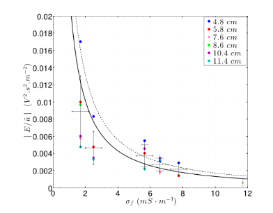
E/ü transfer function measured in an experiment according to the conductivity of the fluid in the porous media (Holzhauer et al., 2015).
E) Geophysical characterization of the site
The purpose of the work done as part of the “geophysical characterization of sites” theme is to study the space and/or time variations in the petrophysical properties of the subsurface (i.e. fracturing, water content, etc.). Research projects are systematically based on data recorded on site, either at the surface, in tunnels/cavities or in the well. The equipment the team has at its disposal allows investigations at hectometric scale and mainly include “high-resolution” seismic and radar methods. Depending on the objectives, electric methods (electric tomography, ERT) complete our range of measurements.
Beyond the imaging objectives (see radar figure below) used to characterize the geological and structural context (stratigraphy, fracturing, etc.) our work is also based on the temporal evolution of the parameters measured, such as the velocity of EM waves, particularly sensitive to water content.
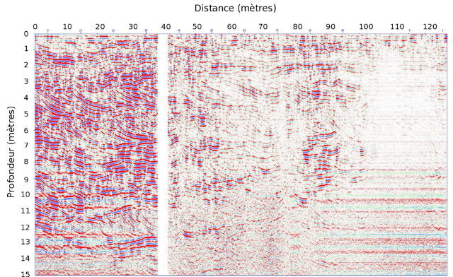
Example of a radar cross-section to image stratification in a limestone environment.
Therefore, the analysis of the evolution of EM velocity models obtained through propagation time tomography (see EM velocity figure) contributes to understanding water circulation in a media of a certain porosity.
Examples of EM velocity models (intra-well tomography) in a karstic environment
The projects carried out in the laboratory concern the characterization of carbonate reservoir analogs, but our capacity to image and characterize the subsurface in the 0-200 m layer means that we can also participate in projects with a wide range of objectives (environmental objectives, archeological sites, seismic risks, georesources, etc.
Permanents members
Charles AUBOURG, PR
Nicolas BEAUDOIN, Chaire junior E2S-UPPA (2018-2022)
Cédric BONNEL, MC
Clarisse BORDES, MC
Daniel BRITO, MC HDR
Jean-Paul CALLOT, PR, Chaire de Géologie structurale
Thibaut de L’HAMAIDE, PAST
Guilhem HOAREAU, MC, Chaire CNRS
Isabelle MORETTI, chercheur E2S (2019-2021)
Bertrand NIVIERE, MC
Dominique ROUSSET, MC
Federici SANJUAN, IR CNRS
Guy SENECHAL, MC
PhD
Yacine KICHE (2016-2019)
Chengyi SHEN (2016-2019)
Arthur BLOIN (2016-2019)
Geoffrey MOTTE (2017-2020)
Pierre-Alexandre GRIGNARD (2017-2020)
Naïm CELINI (2017-2020)
Gulce DINC (2017-2020)
Bruno LECLERE (2017-2020)
Philippine RUTMAN (2017-2020)
Marion BURGIO (2016-, doctorante au GET UMR5563)
Victor MARTINS-GOMES (2018-2021)
Abishek BASA (2018-2021)
Post-doct
Edouard LE GARZIC
Guillaume BARRE
Eider HERNANDEZ BILBAO
Alexandre PICHAT
Esther IZQUIERDO LLAVALL
Etienne LEGEAY
Nathalie ETHEVE
Maxime DUCOUX
Stephen CENTRELLA
Jessica SAIAG
Matthieu BRANELLEC